
Is ‘tornado alley’ shifting?
By Tim Alexander For Chronicle Media — May 23, 2025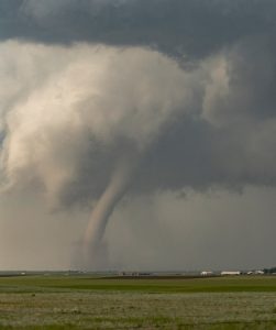
Studies show that based on the number of days per year during which the weather is conducive to the formation of tornadoes, the perceived U.S. “tornado alley” of Texas, Oklahoma and Kansas is shifting to the Deep South and the Midwest.
Near-record-dry soil moisture levels contributed to the May 16 wind-driven dust storm that coated Chicago and much of northwestern Illinois in a pesky layer of dust and debris, according to Emmy-winning CBS Chicago meteorologist David Yeomans.
“That dry soil combined with an incredible straight-line wind gust from a thunderstorm led to a remarkable dust storm that included the Chicago area. This was a full-blown ‘haboob’ that usually only happens in Saudi Arabia, or sometimes in Arizona or Texas. This happened in the city of Chicago, reducing visibility to less than a quarter of a mile during Friday evening rush hour,” Yeomans said during a recent webinar in which he spoke to Illinois farmers about shifting Midwestern weather patterns and increases in extreme weather events.
The meteorologist described the dust layer that encroached Chicago as ranging from 1,000 to 2,000 feet high, kicked up by outflow winds blowing up dust from crop fields and other areas suffering from “anomalously record” dry soils.
“When you have cool air descending from a thunderstorm hitting the ground and spreading out in all directions, if it picks up soil that is how we get into trouble from a significant dust storm. This dust came all the way from central Illinois to the Wisconsin border,” said Yeomans.
When not dealing with haboobs or longer-lasting and more powerful derechos, Illinois residents are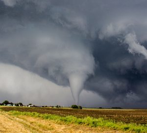 experiencing more tornadic activity than in generations past, according to weather and climate data. In fact, 2024 was a record year for the number of tornadoes recorded in Illinois, with 142 observed throughout the state. Yeomans pointed to recent studies showing that based on the number of days per year during which the weather is conducive to the formation of tornadoes, the perceived U.S. “tornado alley” of Texas, Oklahoma and Kansas is shifting to the Deep South and the Midwest.
Other studies show that there has also been a change in where and when tornadic activity generally occurs.
“We’re now having deadly tornado outbreaks in December, and like in Illinois a couple years ago, in February. These tornado alley shifts are having a huge impact on our weather here,” he said. “In the Chicago area west to Rockford and down toward Peoria and Springfield, last year we had a record 63 tornadoes, beating the previous record from (2023). On average this geographic area of Illinois would only see 15-20 tornadoes per year.”
Meteorologists and climatologists are not only seeing a shift in the geography and frequency of tornadoes, but straight-line winds such as derechos as well. Damaging thunderstorm wind events are becoming more common, including a July 2022 hurricane-force derecho that flattened crop fields and caused billions of dollars in property losses across multiple states, including Illinois.
“We are smack-dab in the middle of where these kinds of things happen most often,” said Yeomans. “In Illinois and Indiana, derechos and widespread damaging wind events typically happen once a year. There are few places in the country or the world where they happen more often.”
Yeomans devoted a portion of his talk to the global rise in seasonal warmth, a key driver in the increase in extreme weather events. Since 1970, 200 cities across the United States have recorded increasingly hotter average seasonal temperature levels, with the greatest average temperature increases recorded in the Southwest and West. In Peoria, the average summer temperature has warmed by almost 3 degrees over the past 54 years.
“It may not seem like much, but 3 degrees over a three-month period, every hour every day, can lead to a huge difference in how plants behave and respond, how crops grow and in the freeze cycle during the wintertime,” he said, adding that from 1920-50 the average date of the first freeze in Rockford was Oct. 5, with the last hard freeze around May 5. From 1990 to 2020 the average first-freeze date was Oct. 15, with the last hard freeze occurring around 10 days sooner than in 1920-50.
“The growing season has been extended, and the cold winter months are getting more compacted as the U.S. warms up,” Yeomans said. “In Chicago, we have records that go 150 years back and the summers are warming up a little less than in Peoria and Rockford, by about 1.7 degrees since 35 years ago. The winters in Chicago have warmed up at twice the rate of that, up 3.5 degrees since 1990. This affects the average number of freezing nights we see in a year, which has been reduced from 132 to 119.”
As for the remainder of 2025, Yeomans cautioned that heavy tornadic activity has sometimes followed a La Nina winter such as the one just past.
“The 1974 tornado outbreak, the 2008 and the 2011 outbreaks across the country all occurred coming out of a La Nina winter, which we are,” he said. “There is another factor that could influence this summer’s tornadic activity, and that is the Pacific-North American pattern that shows where the high- and low-pressure systems are across the globe. Here we just crossed from a positive PNA to a negative PNA, and this is not great news. A negative PNA can mean more tornadoes and more of a severe weather system.”
Trending News
 Pritzker signs executive order responding ...SPRINGFIELD — Gov. J.B. Pritzker signed an executive order July 14 requiring ...
 Northwest Side parish adopts name ...While “The Saint Who Wore Sneakers” sounds like a summer Disney movie ...
 Democratic primary in 9th Congressional ...The ever-growing candidate field for Illinois' 9th Congressional Democratic primary isn’t a ...
 Chicago West Side workforce development ...As Aspire Center for Workforce Innovation, the new workforce development and social ...