
U.S. designates Fox River as part of national Water Trail system
Chronicle Media — June 18, 2023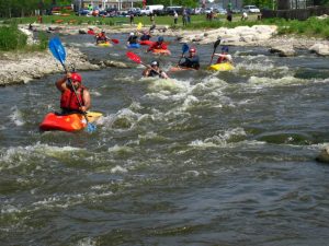
The Fox River running through Yorkville is a great place for paddlers from all over the area to come together. (Photo courtesy of Chicago Whitewater Assoc.)
The National Parks Service has designated the Fabulous Fox! Water Trail as the latest in a series of distinctive network of recreational waterways.
The announcement was made this month by U.S. Secretary of the Interior Deb Haaland as the Fox River would join eight other new National Recreation Trails in nine states.
The trail, a partnership between the states of Wisconsin and Illinois, runs from the headwaters in Waukesha County, Wisconsin, through McHenry, Lake, Kane and Kendall counties in Illinois.
It eventually drains into the Illinois River near Ottawa in LaSalle County.
At 158 miles and with over 70 access points, the water trail offers paddlers the opportunity to enjoy, as well as explore Midwest communities and varying landscapes along the Fox River.
The trail also includes three state parks and intersects with many land-based trail systems.
“Our team is thrilled to become part of the National Park Service,” said Karen Ann Miller, Illinois co-chair of the team developing the Fabulous Fox! Water Trail and Executive Planner with the Kane County Development Department. “This effort could not have been achieved without all of the partners along the Fox River, who for decades have developed and maintained public access and stewarded the River.”
The team of stakeholders from both states that helped develop the trail applied for designation through the National Park Service in November 2022. On June 3, 2023, Harland announced the Fabulous Fox! Water Trail was one of only nine trails across the U.S., selected as a National Recreation Trail in 2023.
“The Fabulous Fox! Water Trail provides a unique way to expand environmental tourism in Kane County while elevating the promotion, awareness and protection of the Fox River,” said Kane County Board Chair Corinne Pierog. “We are proud to have earned this national designation and the tremendous opportunity to make the beautiful waters of the Fox River more accessible to visitors of all backgrounds and abilities who want to get outdoors for recreation, education and adventure.”
The trail includes signage and, in the future, will include strategic infrastructure improvements to enhance water trail access so visitors can enjoy a variety of activities including paddling, fishing, touring historic/cultural sites, dining at local restaurants and shopping.
Maps, itineraries and information on access can be found at https://fabulousfoxwatertrail.org. In addition, downloadable maps are available for 14 segments along the Fox River, which include many paddling itineraries.
Visit https://fabulousfoxwatertrail.org/itineraries/ to see detailed information including number of miles, difficulty, approximate time to finish and interesting features along the route.
According to their website, the National Water Trails are a sub-set of the National Recreation Trails Program and have been established to protect and restore America’s rivers, shorelines, and waterways; conserve natural areas along waterways; and increase access to outdoor recreation on shorelines and waterways.
The National Water Trails System strengthens the conservation and restoration of the waterways through the mutual support and cooperation of federal, state, local and nonprofit entities.
SAMPLE ITINERARY
One of the longest stretches on the Illinois portion is also one of the most rustic and can be managed by paddlers from novice to intermediate. It runs nearly nine miles from Oswego to Plano and includes an adjacent whitewater course in Yorkville.
Put In: Signage from land to carry in at Saw-Wee-Kee Park. This is a developed motorized boat launch. Parking lot and shelter, picnicking, fishing, hiking, biking, bird watching and nature area.
Along the Way: Rural paddle within open landscape and limited development. River widens and narrows around many islands. This stretch is largely rural until you near Yorkville. Paddlers should have some basic knowledge. River current could easily pin a boat in a sweeper, etc. There are small rapids on river right approaching the Yorkville Dam but nothing difficult. The Yorkville Dam stretches three-quarters of the river. Coming up to Yorkville Dam, stay river left to use the recreation rapids chute at Marge Cline Whitewater Course. There is no control gate, so levels are dictated by natural river levels. Canoes can easily use the chute, but kayaks will need spray skirts. The rapids chute can be avoided by portaging just north of chute and walking along the chute to put in below. Past Yorkville Dam water levels may be low. Series of islands on river right suggest that paddlers keep left. A couple of islands downstream from Mill St. bridge and river right are home to a heron rookery. Wild turkeys have been spotted on the ridges on the left bank. Travel past wooded subdivision river right and the Hoover Forest Preserve on river left. Gravel shoals, water willow and shallow channels during low water so generally bear left.
Take Out: Carry out river left at Silver Springs State Park. High power tension lines mark the start of the Silver Springs State Park and the concrete landing will be on the left bank. Parking lot and restrooms, drinking water, shelter, camping, picnicking, playground, fishing, hiking, bird watching, and nature area. Or carry out at Yorkville Bicentennial Riverfront Park, river mile 36.3, river left, includes parking, restrooms, shelter and picnicking. A pedestrian bridge over Marge Cline Whitewater Course to an island, concrete riverfront walk.