
Be prepared for the unpredictable storm season
Judy Harvey — March 16, 2015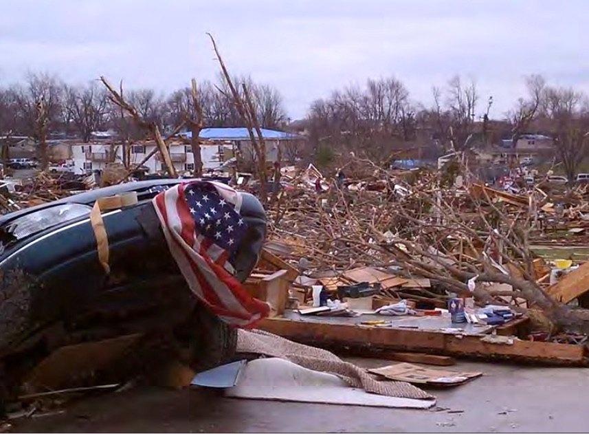
There were 48 tornadoes reported in Illinois during 2014, which resulted in two injuries and nearly $5 million in damage to homes and crops. Photo courtesy of the Illinois Emergency Management Association.
March is the month of transition weather and that means unpredictability ahead. It’s the time of year when talk of severe storms and tornadoes replaces snow storms and polar air blasts in our everyday conversations.
“We need to be prepared for severe weather no matter what time of year it is. Having the preparedness state of mind helps,” said Joe Gillespie, deputy commander with the Kendall County Sheriff’s Department and manager of the county’s emergency management agency.
After all, Illinois springs and summers are known to bring quick weather changes.
“Severe weather and storms should frighten everyone because they are so unpredictable. There is no surefire way to predict a storm’s path because it is nature and we cannot control that,” Gillespie said.
With cable channels devoted to 24/7 weather coverage and digital and social media communications readily available from official agencies, monitoring the weather is now a major part of our daily lives.
“Weather determines how we plan our day, what we wear and planning out our weekends – will we go shopping or stay home and do yard work or just enjoy a nice day. Weather is the news,” Gillespie said.
Social media has changed the landscape of weather coverage as people can instantly post updates and photos in real time from storm events happening in their neighborhood. There is a wider connection over major storm events leading them to have “more of a greater psychological impact than ever before,” he said.
Perhaps that is why there is such an interest in becoming storm chasers and storm spotters. The Kendall EMA helps train and utilizes the latter as part of its network in times of severe weather.
“Storm spotters are not storm chasers. There is a big difference,” Gillespie said. “A storm spotter will usually stay home and report in from their back yard” or if they happen to be out somewhere, he said. They do not actively go out to trail the storm as is seen on so many programs on The Weather Channel or Discovery. Those people are storm chasers.
So who can become an official storm spotter? Anyone between the ages of junior high and older with a real interest in the weather.
“We need people who can call in clear information to the police, to the National Weather Service, to us. We ask that they get the appropriate training once a year,” Gillespie said.
A class was held March 12 at Oswego High School partnership with the Oswego Police, the Kendall County EMA and the National Weather Service, the agency that does the actual teaching. Once completed, the participants can register with the NWS as a trained spotter.
An emphasis is placed first and foremost on safety, Gillespie said, along with knowing the proper method to report information; the keywords used to describe conditions, i.e. size of hail; how storms develop; the difference between a severe weather warning or a watch; and other pertinent information.
When a weather system starts to take a turn for the worst, storm spotters are counted on to be the eyes and ears out in the community and report in the essential facts.
“We want to know wind speeds. We want them to report hail size. Did they see a funnel cloud or was it an actual tornado. A funnel cloud is in the air and it does not become a tornado until it touches ground,” Gillespie said.
Storm spotters have become an integral part of emergency preparedness and meteorological reporting. The NWS depends on “real-time reports from trained spotters to know exactly what is occurring on the ground under a storm,” it states. The trained spotters aid the NWs “via organized communications networks,” according to the web site.
That network includes, but is not limited to, local police and fire departments, county sheriff’s office, the EMA and the regional NWS office, which for Kendall County is located in Romeoville.
The Kendall EMA annually relies upon about 100 trained storm spotters. And when severe weather hits and warnings are issued, the agency calls upon volunteers who help man the operation center along with Gillespie and Tracy Page, executive assistant to the sheriff for Kendall. Page and Gillespie are both full-time employees of the sheriff’s office but also work as leads for the county EMA. Gillespie has been involved with the EMA for 10 years, serving as the manager for the past five.
“We save thousands of dollars by using people already in staff with the county to run the agency. We share a lot of resources,” Gillespie said.
Storm spotters are also trained in preparedness and that is the key for all residents in handling a weather emergency, from blizzards to severe thunderstorms to flooding, he said.
“We push preparedness. If everyone knows what to do it can help all of us. We can’t stop storms but we can prepare people so we can limit the loss of life. Bad things can happen and we all need to be prepared and have plans,” Gillespie said.
Anyone interested in becoming a storm spotter or on developing a severe weather plan, should contact the Kendall County EMA at http://www.co.kendall.il.us/kcema/contact/. The agency does set up a presentations for organizations and businesses.
Tornado Fast Facts
- Illinois ranks fifth in the United States for the most tornadoes per square mile.
- The majority of Illinois tornadoes have occurred between April 1 and June 30 and between the hours of 3 p.m. and 10 p.m. However, tornadoes have occurred every month of the year at all hours of the day.
- Nearly 30 percent of all tornadoes in Illinois occur after dark.
- There is an average of 47 tornadoes each year in Illinois.
- There were 48 tornadoes reported in Illinois during 2014, which resulted in two injuries and nearly $5 million in damage to homes and crops. Thunderstorm Fast Facts
- (Source: Illinois Emergency Management Agency)
- Illinois averages 550 reports of wind damage and large hail annually. The fact is a majority of the property damage and injuries each year is from high winds and large hail rather than from tornados.
- Severe thunderstorms can produce tornadoes, damaging winds, lightning, hail and/or heavy rain.
- High wind from straight-line winds and downbursts can cause more damage than nearly 75 percent of the tornadoes that occur in Illinois.
- Most lightning deaths occur under or near trees and in open fields.
- Lightning is to blame for 31 deaths in Illinois since 1990. EMERGENCY INFORMATION NETWORKThe National Weather Service Forecast Office websites for the Chicago area is www.weather.gov/chicago.
- Listen to NOAA Weather Radio-All Hazards for the latest weather forecasts. The National Weather Service broadcasts weather information 24 hours a day, including watches, warnings and advisories. Weather radio transmitters have a range of about 40 miles. For Kendall County, the frequencies are Plano- 162.400 and Lockport – 162.425. For more information go to: http://www.nws.noaa.gov/nwr/CntyCov/nwrIL.html. and http://www.crh.noaa.gov/lot/?n=severeprepare
- (Source: Illinois Emergency Management Agency)
Trending News
 Chicago teen charged in fatal ...A 19-year-old Chicago man has been charged in connection with a fatal ...
 Government, defense spar as child ...With the criminal trial of Elburn veterinarian Adam Stafford King fast approaching ...
 Challenges persist for women, minorities ...PEORIA — For 60 years, SkillsUSA Illinois has held workforce development competitions ...
 Chicago officials seek to allay ...Chicago officials tried to reassure Pilsen neighborhood residents that they are doing ...