
Lake County’s legendary ‘Millburn Strangler’ enters engineering phase
Gregory Harutunian For Chronicle Media — June 21, 2017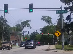
The “Millburn Strangler” encompasses a zig-zag pattern along Route 45, and split intersections with Grass Lake and Millburn roads. The traffic signals also contain protected turns, which have created legendary vehicle snarls. (Photo by Gregory Harutunian/for Chronicle Media)
One of Lake County’s most notorious traffic congestion points is closer to becoming a thing of the past, as the Illinois Department of Transportation has entered the Phase II engineering portion in addressing the “Millburn Strangler,” with actual construction expected to go out for bidding later this year. Right-of-way and easement acquisitions are the lone concerns remaining to the project.
Located in the Millburn historical district, of Old Mill Creek, U.S.Route 45 traverses a staggered set of intersections with Millburn Road, and Grass Lake Road, approximately one block to the north. Traffic signals with protected turns, vehicle congestion during peak morning and afternoon travel times in all directions, and a lack of signal synchronization combined to create miles-long backups.
The effort to correct the problem gained traction in 2009, when a panel of county, state, and federal highway officials met to discuss eighteen proposed roadways as alternatives. It was reduced to a selection of three roadways, two that led west of Route 45, and one that skirted to the east.
Alternative 4 was the preferred choice, a four-lane western bypass in Lindenhurst, from Country Place to Independence Boulevard. The 7,200-foot pathway was given a $34 million allotment from the county, nearly 13 acres from the proximal county-owned McDonald Woods, and potential link-ups with bike paths. Lindenhurst completed a bike underpass on Grass Lake Road, which opened last year, just east of the planned bypass.
“The Lindenhurst Park District dug the bike path, and its east of there (Alternative 4), and the project also clips a piece of McDonald woods,” said Chuck Gleason, the Lake County Division of Transportation liaison to IDOT. “IDOT took over, and the Phase I planning part is completed, and the preferred alternative is what the engineering plans are being targeted on. They will actively seek construction bids on the project, slated for Sept. 17.
“There could be a possible delay to wrap up easements and right-of-way purchases, pushing it into November, but the county has committed $34 million to this effort and it was all through the county’s portion of the retail sales tax, which is one-quarter percent,” he said. “Any overages, or cost overruns, will be covered by the state.”
The funding for the county’s financial end was made in 2011. The county’s Forest Preserve District also decided to sell the 13 acres of the Mc DonaldWoods, as opposed to permitting an easement. IDOT will also build a shared-use path along the west side of the bypass, with a sidewalk on the east side. A section from McDonald Woods to Independence boulevard is set to become part of the Millennium Trail, the 42-mile bike trail connecting most of Lake County.
The western bypass was also chosen for its adaptability to future migration patterns and population projections. IDOT noted that the “Average Daily Traffic” for U.S. Route 45 at Millburn Road is projected to double to approximately 30,000 vehicles per day, by the year 2040, as compared to the current 16,000 vehicles per day. The increase in traffic along U.S. Route 45 is anticipated even if no improvements are made.
A FAQ statement noted, “Based on the analysis of projected year 2040 travel performance for all vehicles in the study area, during the peak evening travel period, the west bypass (Alternative 4) would have superior performance with the lowest cumulative travel time … the lowest cumulative travel delay … and the best p.m. peak level of service (LOS) for the main intersection of the U.S. Route 45 bypass and Grass Lake Road and/or Millburn Road, traveling through the intersection.”
Residential growth in the areas surrounding the Millburn area have increased in the past decade, and contributed to the traffic congestion, leading to questions regarding a lack of overall planning for population density.
“These residential developments are all within municipal, or incorporated boundaries,” Gleason said. “The county, or IDOT, for that matter, can only issue access permits to the roadways.
“Density is community zoning, and their jurisdictions. If there is oversaturation, it is the community in the planning. There is a lot of commuting from other areas to the intersection also. So, the congestion is not just from one, or several areas,” he said.
IDOT has indicated that of 31 parcels for right-of-way for the western bypass, two parcels are still actively in discussions. The actual construction is anticipated to begin by spring 2018.
–County’s legendary ‘Millburn Strangler’ enters engineering phase–
Trending News
 Hinsdale couple file $500 million ...A Hinsdale couple have filed a $500 million claim against a car ...
 Renovations close RiverEdge for seasonAurora’s RiverEdge Park is known around northern Illinois as a gem when ...
 Suspect charged in fatal Streamwood ...A suspect has been charged in connection with the stabbing deaths of ...
 Peoria County losing a legal ...Federal budget cuts directed by President Donald Trump’s Department of Governmental Efficiency ...