
Heavy rains continue to soak Illinois in July
Chronicle Media — July 13, 2015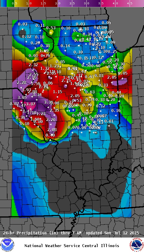
This National Weather Service map shows the rainfall totals during a 24-hour period through July 12 with more rain expected across much for the state today (July 13).
In the past 24 hours, July 11-12, much of Illinois has been hit once again with major storms bringing high winds and heavy rainfall. This marks another day of rain during a record-setting summer of rain.
Peoria and Qunicy reporting some of the highest 24-hour totals, of 2.15 and 3.8 inches, respectively, but many areas, including Bloomington/Normal and were reporting close to an inch or more from Sunday evening into Monday morning, according to the National Weather Service (www.weather.gov/ilx/precip).
For some communities and counties, this latest storm front just piles on the rain hat has saturated the ground and caused flooding of local creeks and rivers this summer.
According the Climate Data from the National Weather Service, some of the highest total for July are :
Quincy – 6.22
Peoria – 3.96
Decatur – 3.97
Cahokia/St. Louis – 3.57
The Chicago suburban counties are reporting at or above 1 inch for July and more rain coming throughout the day and evening Monday evening.
These high totals already for July come after the record-setting rainfall for June, when the average across Illinois was at 8.9 inches.
Trending News
 Three men shot – one ...Three men were shot – one fatally -- Saturday afternoon on Chicago's ...
 Government, defense spar as child ...With the criminal trial of Elburn veterinarian Adam Stafford King fast approaching ...
 Chicago teen charged in fatal ...A 19-year-old Chicago man has been charged in connection with a fatal ...
 Challenges persist for women, minorities ...PEORIA — For 60 years, SkillsUSA Illinois has held workforce development competitions ...