
‘Millburn Strangler’ bypass enters construction phase
By Gregory Harutunian For Chronicle Media — August 15, 2018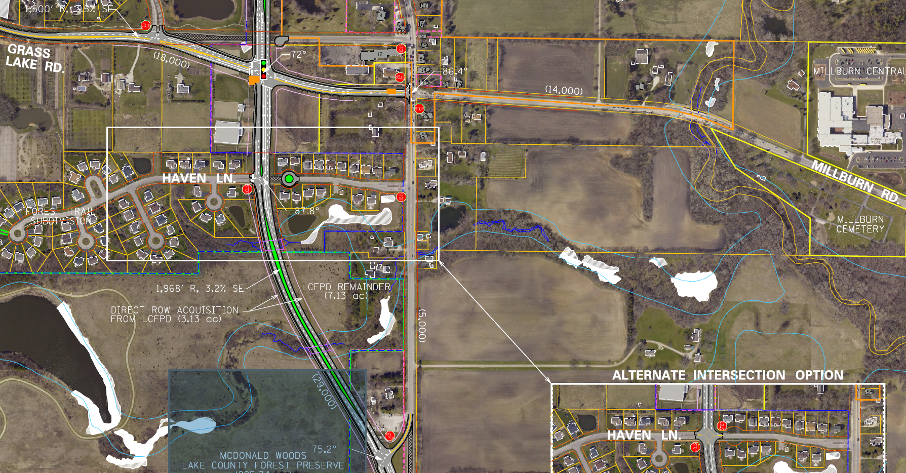
A detail highlight of the western bypass plat map showing the Grass Lake Road intersection. (Courtesy of Illinois Department of Transportation)
With the Phase II engineering completed, construction for the remedial action on one of Lake County’s most notorious traffic congestion points is underway.
The “Millburn Strangler” has vexed traffic flow patterns along Route 45 for decades, coupled with staggered intersections at Grass Lake and Millburn roads, along with graduated area residential and commercial growth.
Utility companies were the first to break ground for the relocation of service lines last month, as motorists were alerted to potential lengthy delays caused by one-lane traffic and shifting construction zones. Located in the Millburn Historical District, of Old Mill Creek, U.S. Route 45 often hosts mile-long traffic backups, during peak morning and afternoon travel times caused by a lack of synchronization with signal lights between intersections, less than one block apart.
“They started construction last month, and the contractor is working with the utility companies to make sure their requirements are met,” said Chuck Gleason, project manager for the Lake County Division of Transportation. “Once the project went out to bid, and the job order was accepted, it became an Illinois Department of Transportation project, and they are overseeing everything.”
Bidding began in April, with Wauconda-based Berger Excavating, Inc. being awarded the job order as contractor, Gleason said. The accepted bid amount is $15.58 million.
Utility work crews laid underground piping along south Route 45’s eastern side last month, as part of a relocation platting for their networks. North Route 45 is subject to rotating lanes closures with openings for connector portions dotting the thoroughfare and roads to the east and west. Trees have been removed along the bypass path, and one house on Grass Lake Road has been boarded and blocked off, while set for demolition.
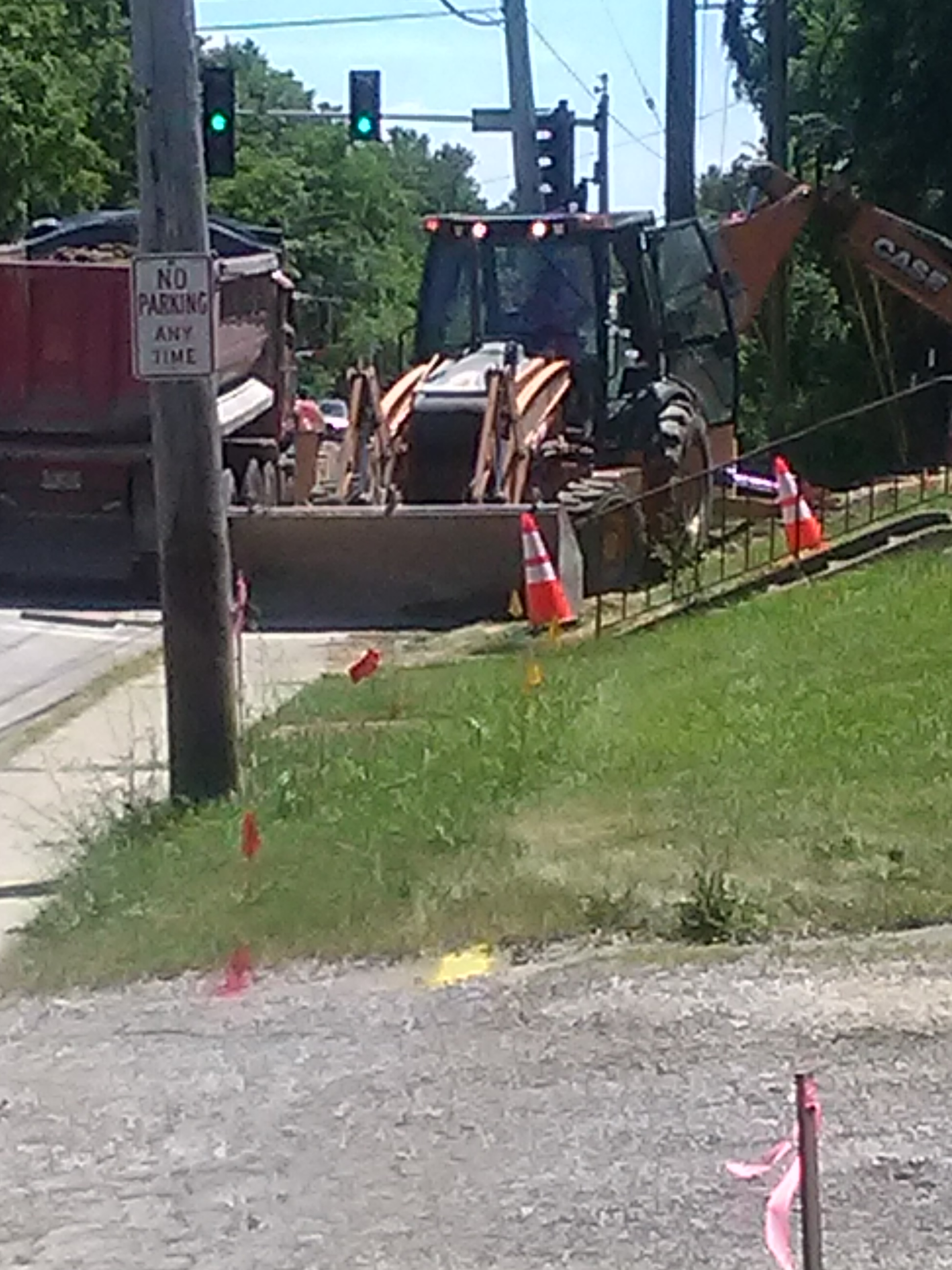
Utility company crews work to relocate piping along the bypass roadway. (Photo by Gregory Harutunian/for Chronicle Media)
Although an IDOT project, the county had committed $34 million to the project from its portion of the retail sales tax, set at .25 percent, which was made in 2011. Cost overages and overruns are being paid by the state, which also worked on 31 parcels for easement acquisition. The four-lane western bypass follows a 72,000-foot bell-shaped access within Lindenhurst municipal boundaries, from Country Place to Independence Boulevard.
The Lake County Forest Preserve also sold a 13-acre parcel of the county-owned McDonald Woods to the state, rather than simply allow an easement. IDOT will also build a shared-use path along the western perimeter of the bypass, paralleled by a sidewalk on the east side. A section, from McDonald Woods to Independence Boulevard, is also set to become part of the Millennium Trail, the 42-mile bike trail connecting most of Lake County.
The bypass effort gained traction in 2009, when a panel of county, state, and federal highway officials met to discuss 18 proposed alternative roadways. Relieving traffic congestion was the main focus, along with skirting unmarked graves and homes in the Millburn Historic District.
Construction will widen Route 45 to a four-lane highway, while its existing intersections will be designated as Old Route 45 and controlled by stop signs. The bypass intersection at Grass Lake Road will have a traffic signal device. Stop signs will likewise control traffic at the Haven Lane access point in the Forest Trail subdivision, and Heritage Drive in the Heritage Trails subdivision. The section from Independence Boulevard, north to Route 45 is 1,400 feet.

The intersection of Route 45 and Millburn Road is reduced to one lane of traffic to accommodate work crews. (Photo by Gregory Harutunian/for Chronicle Media)
The western bypass was labeled as “Alternative 4,” of the four choices filtered down from original concepts and selected by state engineers as being the most viable. Initial public reaction favored an eastern bypass. IDOT noted that the average daily traffic for U.S. Route 45 at Millburn Road is projected to double to approximately 30,000 vehicles per day, by the year 2040. Its current usage was pegged at 16,000 vehicles per day.
“Based on the analysis of projected year 2040 travel performance for all vehicles in the study area, during the peak evening travel period, the west bypass (Alternative 4) would have superior performance with the lowest cumulative travel time … the lowest cumulative travel delay … and the best p.m. peak level of service for the main intersection of the U.S. Route 45 bypass and Grass Lake Road and/or Millburn Road, traveling through the intersection,” according to a study document on the project website.
—- ‘Millburn Strangler’ bypass enters construction phase —-
Trending News
 With scant notice, Rockford hospital ...Residents on Rockford’s west side are feeling abandoned and betrayed after Javon ...
 Three men shot – one ...Three men were shot – one fatally -- Saturday afternoon on Chicago's ...
 State ends fiscal year with ...Despite uncertainty over the economy and federal funding during the second half ...
 USA’s 249th birthday celebration marked ...Independence Day fireworks shows are as old as the nation itself. According ...