
Groups release plan for South Side riverwalk
By Igor Studenkov For Chronicle Media — July 24, 2024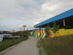
Street art at the Prologis Riverwalk (Photo by Igor Studenkov/for Chronicle Media)
A group of community organizations representing neighborhoods along the South Branch of the Chicago River is looking to build a riverwalk that would go from Chinatown’s Ping Tom Memorial Park to Western Avenue.
The South Branch Connectivity Project Framework Plan, which was unveiled at the McKinney Park branch library, presents a vision for improving the south bank of the river and its surroundings. While there are some riverwalks and parks in the area, it is still mostly defined by active and abandoned industrial uses. Anyone who wants to follow the river now needs to make multiple detours, often taking roads that don’t have sidewalks.
The plan is spearheaded by the McKinley Park Development Council, with assistance from the Coalition for a Better Chinese American Community, Bridgeport Alliance, Living Habitats architecture firm and University of Illinois Chicago’s College of Urban Planning and Public Affairs. The organizations did community research and worked with various city departments, the Chicago Park District and U.S. Army Corp of Engineers. Chicago is expected to take the plan into account when approving future projects.
The city already requires developments along the south bank to provide space for a riverwalk. However, as MPDC president Kate Eakin acknowledged in her plan presentation, there isn’t much the city can do if a property owner wants to keep things as they are.
There are some infrastructural challenges. For example, in order to connect to Ping Tom Park, the riverwalk would need to cross railroad tracks used by two Metra lines and most Amtrak routes.
The south branch within the study area flows southwest until it reaches the Chicago Sanitary and Ship Canal at Damen Avenue. A tributary officially known as South Fork but colloquially known as Bubbly Creek joins the river a little east of Ashland Avenue.
For much of the city’s history, the Chicago River wasn’t seen as a recreational destination. Factories, warehouses and rail yards lined its banks all the way up to Michigan Avenue. That began to change in the 1980s, but most of the river west of Ping Tom Park retained its industrial character.
As the framework plan notes, the areas around the South Branch and Bubbly Creek “host a variety of
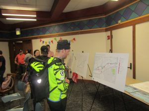
Residents look at the display boards during a South Side riverwalk framework plan meeting. (Photo by Igor Studenkov/for Chronicle Media)
light industrial facilities, including recycling and solid waste, concrete and asphalt production, logistics and shipping, construction, wholesale produce, data centers, and automotive supply, in addition to ComEd electric substations and the River’s Edge shopping mall in Bridgeport.”
Remediation from over a century of pollution is an ongoing issue, especially near Ashland Avenue.
There are already some parks on the shoreline, complete with multi-use paths and other amenities.
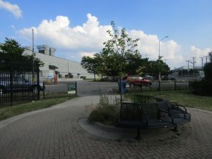
Canalport Riverwalk runs between Santa Fe Slip, roughly parallel to Wood Street, and Ashland Avenue. The smaller Canal Origins Park is located on the other side of Ashland Avenue, along Bubbly Creek. Park 571 is located on the other side of Bubbly Creek, and Prologis Riverwalk begins further east, along the east end of the ComEd substation, and stops at Halsted Street.
This leaves significant gaps in the riverwalk coverage — best demonstrated by how the trail at Park 571 dead-ends at the fence around the abandoned People’s Gas property.
The plan also flags accessibility as an issue. For example, Canalport Riverwalk is easy to reach from the Ashland Avenue end, but to reach the west end, residents currently need to take a stretch of 29th Street that has no sidewalks and is used by trucks serving the Anthony Marano Co. Grocery wholesaler complex.
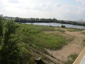
Vacant land west of Damen Avenue (Photo by Igor Studenkov/for Chronicle Media)
The plan divides the study area into three segments. At Segment A, which spans the section between Western and Ashland avenues, there are two properties poised for development. SageNet LLC property directly east of Western Avenue is currently up for sale, and MAT Asphalt, which bought the abandoned grain silos east of Damen Avenue (locally known as “Damen Silos”) is looking to demolish the existing structures. Under the city Chicago River Design Guidelines, any new development along the south riverbank needs to include a 30-foot setback by the riverbank to provide room for a riverwalk.
Eakin said that the stumbling block is the BNSF Railway-owned land between the two aforementioned properties. The railroad has shown no interest in moving, and the city can’t legally compel it to build a riverwalk.
“I think getting from Western to Damen, not including the silos, is probably going to take the longest,” Eakin said.
For Segment B, which includes the section between Ashland Avenue and Stevenson
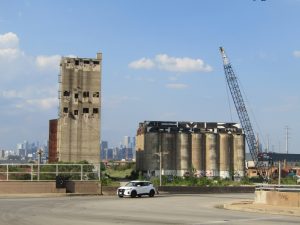
The Damen Silos. (Photo by Igor Studenkov/for Chronicle Media)
Expressway/Dan Ryan Expressway interchange, the plan for a bridge over Bubbly Creek near Hillock Avenue to better connect Channel Origins Park and Park 571. There are currently three sites between the latter and Prologis Riverwalk — the People’s Gas property, the Brandenburg Industrial Services campus and the ComEd substation.
Eakin said that, while MPDC “haven’t heard anything official yet,” Brandenburg “have moved all of their equipment and personal out, and we assume they will sell.” If a new owner redevelops the property, the riverwalk easement requirement will kick in. The city could buy the People’s Gas site for future recreational use, but it would need to be remediated first.
With ComEd substation, the plan calls for negotiating with the utility company to allow the city to use the existing 10-foot setback, which is currently fenced off, and paving it properly.
Delete CacheEast of Halsted Street, there is no space to build a riverwalk — but the plan sees a Canadian National Railway access road a little further south, alongside the railroad embankment, as a possible connection to Grove Street.
“There is dirt track owned by the railroad, and the only thing [obstacle] from getting there is a wall about [knee high],” Eakin said.
The trail would then follow Grove Street, a relatively quiet residential street in Bridgeport and
The Canalport Riverwalk (foreground) coexists with active industry (background). (Photo by Igor Studenkov/for Chronicle Media)
Chinatown, as far as Cermak Road. The trail would then either follow the shoreline or divert further inland. But Eakin said that connecting either option to Ping Tom Park would be “biggest engineering challenge” the project faces, because the busy Amtrak/Metra rail line is at street level, and there aren’t many opportunities to go over or under it.
More generally, the plan calls for reusing as much of the old industrial structures as possible, creating more green spaces, more places where people can hang out and relax, better access to the water and incorporating public art, especially on underpasses and fences.
“[ComEd] needs to have security fence, nobody needs to get electrocuted, but it doesn’t need to be ugly,” Eakin said.
State Rep. Theresa Mah, D-Chicago, whose district includes much of the project area, said during the meeting that the plan demonstrated the power of the community.
“I appreciate all the work that has gone into getting us to this point,” she said. “It’s incredibly valuable, it’s going to be something that’s going to improve our community. And we’re seeing [something] that was only possible because neighbors come together.”
Trending News
 Man killed on South SideA 35-year-old man was killed Thursday morning on Chicago's South Side. Police ...
 One killed, another injured in ...One man was killed and another man was injured Monday night in ...
 Statewide childhood lead testing plannedNearly 13 percent of the 1,350 Illinois ZIP codes at high risk ...
 Chicago man charged with hate ...A Chicago man faces multiple felonies in connection with properties being defaced ...